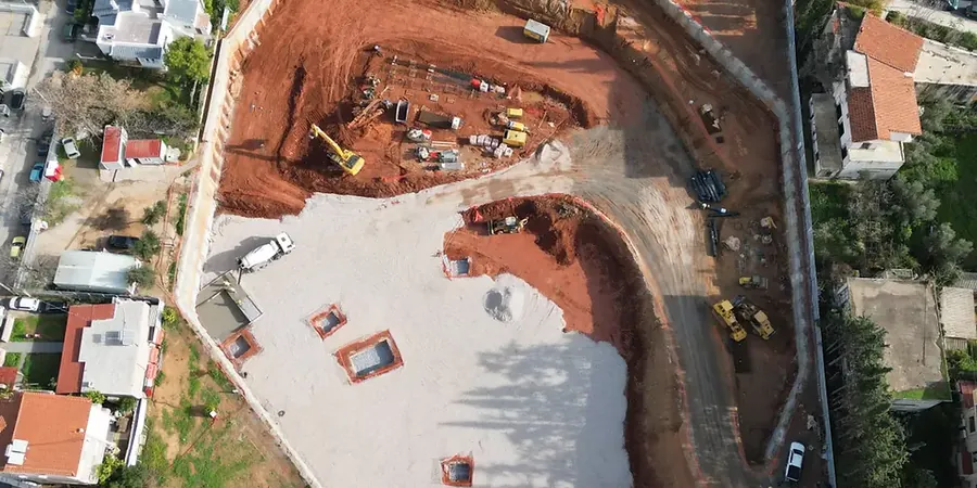
In Omaha, you quickly learn that the ground beneath downtown isn't the same as what you find out west past 120th Street. The Missouri River floodplain and the loess-mantled bluffs each bring their own challenges to a deep cut. We have seen projects where a five-meter excavation in the downtown area hit water sooner than anyone expected, simply because of how the alluvial sand layers pinch and swell across the site. That is why deep excavation here starts with reading the landscape, not just the bore log. A solid design must account for the seasonal rise of the water table, the occasional pockets of fat clay, and the proximity of century-old brick utilities that do not tolerate much movement. Combining experience from the Old Market district to the Aksarben corridor, we integrate local stratigraphy with practical shoring sequences, often tying in slope stability concepts when the cut transitions near a bluff line and retaining walls when right-of-way is tight against adjacent structures.
In Omaha, a deep excavation design that ignores perched water in the loess is a plan for a very wet morning.
Methodology and scope
Local considerations
Omaha sits in a moderate seismic zone, and while the big one gets less attention here than in California, the deep soft soils along the Missouri River valley can amplify ground motion in ways that matter for a temporary excavation support system. A 2008 USGS update put parts of Douglas County in Site Class D and E conditions, meaning a braced excavation designed only for static earth pressures could see an extra kick during a moderate event. Liquefaction of loose alluvial sands below the cut is another concern we evaluate routinely, using SPT-based methods from Youd and Idriss. Beyond seismic, the biggest risk is often the water. The Missouri River stage can fluctuate several feet in a wet spring, and that directly affects pore pressures behind a shoring wall. A design that does not account for rapid drawdown or a sudden rise in the river level can find itself with a soft bottom heave and a very unhappy crew. We also deal with the legacy of Omaha's industrial past: undocumented fill, old rail spurs, and buried foundations that turn a straightforward excavation into a lesson in archaeology.
Applicable standards
ASCE 7-22 (Seismic earth pressures), OSHA 29 CFR 1926 Subpart P (Excavation safety), FHWA GEC 4: Ground Anchors and Anchored Systems, ASTM D1586-18 (SPT for liquefaction assessment), ACI 318-19 (Structural concrete for shoring walls)
Associated technical services
Shoring Wall Design
We develop soldier pile, sheet pile, and secant pile wall designs calibrated to Omaha's loess and alluvial profiles, including cantilever and multi-level braced configurations per IBC and FHWA guidelines.
Dewatering and Groundwater Control Plans
Tailored dewatering strategies using wellpoints, deep wells, or grout curtains to manage the Missouri River-influenced water table and perched zones within the loess mantle.
Excavation Monitoring and Peer Review
Third-party review of contractor submittals plus instrumentation plans using inclinometers, settlement points, and piezometers to verify performance against design predictions.
Typical parameters
Frequently asked questions
How deep can a braced excavation go in Omaha's downtown soils?
We routinely design excavations down to about 12 meters (40 feet) with soldier piles and internal bracing. Deeper cuts, such as for a deep pump station, generally require secant piles or diaphragm walls and a very careful look at the Missourian shale bearing capacity. The practical limit depends more on groundwater and adjacent structures than on the soil strength alone.
Do I need a dewatering plan for a five-meter excavation near the Missouri River?
Almost certainly yes. The river stage controls the alluvial aquifer level, and even a cut that stays above the average water table can intercept perched water in the loess. A dewatering plan is not optional if you want dry working conditions and a stable excavation bottom.
What seismic factors apply to a temporary shoring design in Omaha?
Per IBC and ASCE 7, we evaluate the site class and apply seismic earth pressure increments where the design ground motion exceeds 0.10g. In the river valley, Site Class D or E can push those pressures up enough to change the bracing layout, so we run a site-specific response analysis for deeper cuts.
What is the typical cost range for a deep excavation design in Omaha?
For a full design package including shoring wall drawings, dewatering plan, and construction-phase monitoring specifications, projects in Omaha generally range from about US$1,880 for a straightforward single-family lot cut to US$9,150 for a complex multi-level braced excavation in the downtown core.
How long does the design process take from site investigation to issued-for-construction drawings?
A typical timeline runs three to five weeks after we receive the geotechnical report. That allows for earth pressure modeling, structural analysis of the wall and bracing, coordination with the structural engineer on connections, and two rounds of review. Fast-track projects can be turned in under two weeks when the soil conditions are already well understood.