A five-story mixed-use structure on Capitol Avenue had excavation plans extending 22 ft into the underlying Peoria Loess. The geotechnical review flagged a 38-degree cut face with visible seeps after rain. That scenario repeats across Omaha's eastern corridor, where loess-mantled bluffs drop sharply toward the Missouri River floodplain. Traditional bearing-capacity checks miss what slope stability analysis catches: the progressive loss of matric suction during wetting fronts, the role of relic jointing in loess, and the real influence of a 14-ft-deep water table perched above glacial till. For this project the team ran limit-equilibrium profiles using Spencer's method and coupled the output with a deep excavation monitoring plan to track lateral deformation during basement construction.
Loess can hold a 70-degree face in dry weather and fail at 35 degrees after three days of rain — slope stability is a moisture-triggered problem.
Methodology and scope
Local considerations
Omaha's expansion westward into the Elkhorn River basin and eastward redevelopment along the Missouri riverfront has placed structures on slopes that were pastureland thirty years ago. The city's combined sewer overflow tunnels, bored through weathered shale beneath downtown, added a new category of risk: slope unloading during tunnel excavation triggering settlement in overlying loess. A 2016 cut failure near Hanscom Park — a 55-ft-wide rotational slide in saturated loess — cost the developer six months of delay and a $400,000 retaining-wall redesign. That slide started at a 2H:1V slope that had been stable for eighteen months. The trigger was a broken water line. Slope stability analysis that accounts for transient seepage, not just steady-state groundwater, would have flagged the vulnerability. The lesson is that Omaha's loess demands a rainfall-triggered failure scenario in every analysis package.
Applicable standards
FHWA-NHI-05-123: Soil Slope and Embankment Design, ASTM D4767-11: Consolidated Undrained Triaxial Compression Test for Cohesive Soils, IBC 2021 Section 1610: Soil Lateral Loads, ASCE 7-22 Chapter 11: Seismic Design Criteria (Omaha site class C/D boundary), Eurocode 7 EN 1997-1:2004 (Geotechnical Design) for FoS methodology
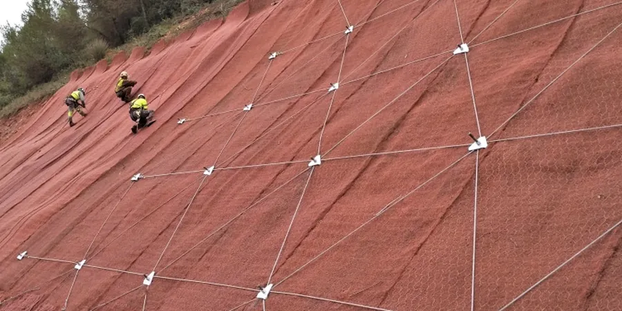
Associated technical services
Rotational and Translational Slide Analysis
Limit-equilibrium modeling (Spencer, Morgenstern-Price) for cut and fill slopes in loess, glacial till, and colluvium. Includes back-analysis of observed failures to calibrate strength parameters.
Seismic Slope Stability
Pseudo-static and Newmark displacement analyses using site-specific PGA values for Omaha. Evaluates liquefaction-induced flow failure in sandy interbeds within loess and alluvial deposits.
Reinforcement and Remediation Design
Soil nail, ground anchor, and MSE wall designs to achieve target FoS. Includes drainage specification — trench drains, horizontal wick drains, and surface-water diversion — critical for loess slope longevity.
Typical parameters
Frequently asked questions
What is a typical factor of safety for a permanent cut slope in Omaha loess?
We target a static factor of safety of 1.5 for permanent cuts, in line with FHWA-NHI-05 recommendations. For temporary construction slopes, 1.3 is acceptable. These values assume drained strength parameters from triaxial testing and a groundwater model that reflects wet-season conditions.
Does Omaha's seismic setting affect slope stability requirements?
Yes. Though Omaha is not in a high-seismicity zone like the West Coast, the Nemaha Ridge and Humboldt Fault systems generate a design PGA around 0.08–0.12g on Site Class D. We run pseudo-static analyses and, for critical slopes, Newmark displacement calculations to ensure deformations stay within tolerable limits.
How much does a slope stability analysis cost for a typical commercial site in Omaha?
The cost typically falls between US$1,390 and US$4,560, depending on the number of cross-sections analyzed, whether seismic loading is included, and the amount of field investigation needed to define the subsurface model.
How long does a slope stability investigation take from start to finish?
A standard analysis with two to three critical cross-sections takes about three to four weeks. That includes drilling or test pitting to sample the loess and underlying till, laboratory triaxial or direct shear testing, modeling, and reporting. Projects requiring piezometer installation for groundwater monitoring may add one to two weeks.