A stretch of freshly compacted subgrade along Dodge Street might look solid from the cab of a grader, but the difference between a pavement that survives Omaha’s freeze-thaw cycles and one that fails in three years comes down to measured density. The silty loess and clayey alluvium that blanket the metro area respond to moisture in ways that density logs alone cannot capture, which is why we run the sand cone on lifts where the proctor curve was built from borrow on site. When the Nebraska Department of Transportation specifies 95 percent of standard Proctor maximum dry density, the number on the report has to be more than a calculation—it has to reflect what the roller actually achieved under the morning’s humidity. For deeper fills near the Missouri River floodplain, we often pair the sand cone with a Proctor test to anchor the reference curve to the same material being placed, because recompacted loess can shift optimum moisture by two or three points between the borrow pit and the lift.
A sand cone test that takes an extra ten minutes to dry the moisture sample properly can save a full day of re-compaction after the first freeze.
Methodology and scope
Local considerations
Omaha sits at an elevation of roughly 1,090 feet on the western bank of the Missouri River, and much of the commercial construction east of 72nd Street is built on Pleistocene loess that is metastable when wetted. A compaction test that reads 98 percent at placement can drop below 92 percent after a single heavy rain if the fill was compacted dry of optimum on a warm October afternoon. We have pulled sand cone samples from utility backfill in Benson where the dry density was acceptable but the moisture content was four points below optimum, and the resulting collapse settlement cracked a newly poured curb within eight months. The sand cone method catches these conditions because it forces the technician to handle the soil, observe its color and texture, and record the moisture sample correctly—steps that automated gauges skip. In cohesive fills near Carter Lake, where the water table is shallow and the clay can be overworked by a sheepsfoot roller, the percent compaction number alone does not tell the full story; the sand cone data combined with a triaxial shear test on the same material can reveal whether the soil structure is gaining strength or just being remolded into a denser but weaker fabric.
Applicable standards
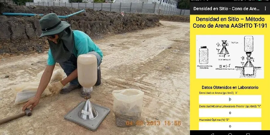
ASTM D1556-15e1: Standard Test Method for Density and Unit Weight of Soil in Place by Sand-Cone Method, AASHTO T 191: Density of Soil In-Place by the Sand-Cone Method, ASTM D698-12: Standard Test Methods for Laboratory Compaction Characteristics of Soil Using Standard Effort, ASTM D2216-19: Standard Test Methods for Laboratory Determination of Water (Moisture) Content of Soil and Rock by Mass, Nebraska Department of Transportation – Standard Specifications for Highway Construction, Section 203
Associated technical services
Standard Proctor Reference Curves
Laboratory compaction curves per ASTM D698 for each distinct borrow source, establishing the maximum dry density and optimum moisture content that the sand cone percent compaction is measured against.
Field Moisture Content by Oven-Dry Method
Companion moisture determination per ASTM D2216 performed on the excavated sand cone sample to calculate dry density and verify whether compaction occurred within the specified moisture range.
Nuclear Density Gauge Correlation Panels
Construction and calibration of site-specific correlation panels where the sand cone provides the reference density to adjust nuclear gauge readings for local soil mineralogy and moisture conditions.
Utility Trench Backfill Verification
Sand cone testing within narrow trench excavations across Omaha’s MUD and OPPD corridors, where access constraints and safety requirements demand a method that needs no electronics and minimal clearance.
Typical parameters
Frequently asked questions
What does a field density test with the sand cone method cost in the Omaha area?
A single sand cone test in Omaha typically runs between US$110 and US$140 per point when performed as part of a larger compaction control program, with pricing influenced by the number of points per day, travel distance to the site, and whether a companion Proctor curve already exists for the material.
When is the sand cone method required instead of a nuclear density gauge in Omaha?
The sand cone is specified when the fill contains high-organic silts common in the Missouri River floodplain, when trench widths are too narrow to meet the nuclear gauge’s source-detector geometry requirements, or when the contract documents explicitly require an ASTM D1556 direct volume measurement for acceptance testing of structural backfill.
How many sand cone tests are needed per lift of compacted fill?
The frequency depends on the project specifications, but a typical commercial site in Omaha requires one test per 2,000 to 3,000 square feet per lift, with additional tests at any location where the roller operator reports a change in soil behavior or where proof-rolling identifies a soft spot that was reworked.
How long does a sand cone density test take to perform and get results?
The field procedure itself takes about 15 to 20 minutes per point, plus the time required to oven-dry the moisture sample in the laboratory, which typically adds 16 to 24 hours. We provide the final dry density and percent compaction the following business day, though preliminary wet density values are available immediately on site.