Soil in Dundee rarely behaves like soil in South Omaha. The silty loess on the bluffs drains quickly but can collapse when loaded; down by the Missouri River, the alluvium holds fines that swell and retain water. A standard SPT boring tells you blow counts, but without a full grain size curve you miss the percent passing #200 — the single number that separates a settlement-prone ML from a frost-susceptible CL. We run every sample through both sieve stack and hydrometer, merging the two into one continuous distribution. The result is a USCS classification backed by measured numbers, not guesswork, referenced to ASTM D2487 and our ISO 17025 scope.
Percent passing the #200 sieve is the single most expensive number to get wrong in Omaha — it flips the USCS group symbol and changes everything from bearing capacity to frost design.
Methodology and scope
Local considerations
The Missouri River floodplain deposits across eastern Omaha contain lenses of fat clay with liquid limits above 50 — material that can slip at 2:1 slopes when saturated. We have pulled hydrometer samples from twelve-foot-deep borings near Carter Lake that read 60% clay fraction and still looked like silt to the field crew. Getting the grain size wrong on these soils means undersized stormwater detention volume, cracked slab-on-grade, or a retaining wall that overturns after the first wet spring. The unified classification is not academic: it feeds directly into the allowable bearing pressure tables in IBC Chapter 18 and the lateral earth pressure assumptions in your retaining wall design.
Applicable standards
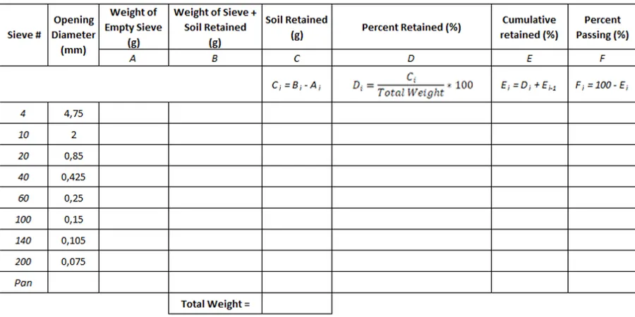
ASTM D6913 / D7928 — Particle-size distribution (sieve + hydrometer), ASTM D2487 — Unified Soil Classification System (USCS), NDOT Standard Specifications for Highway Construction (gradation bands)
Associated technical services
Sieve-Only Gradation (ASTM D6913)
Mechanical sieve stack from 3 inches to No. 200. Ideal for clean sands and gravels encountered in western Douglas County. Delivers percent retained on each sieve, percent passing #200, and USCS group symbol when fines are below 12%. Typical turnaround 2 business days.
Combined Sieve & Hydrometer (ASTM D6913 + D7928)
Full particle-size curve for fine-grained soils common in the Missouri River corridor. Includes 24-hour sedimentation reading, deflocculated hydrometer analysis, and merged gradation plot. Required for frost-susceptibility classification and most NDOT pavement subgrade evaluations.
Typical parameters
Frequently asked questions
How much sample material do you need for a combined sieve and hydrometer test?
We ask for at least 500 grams of material passing the No. 4 sieve. If the field sample is limited — say from a thin silt seam in a Shelby tube — we can run a micro-scale hydrometer, but it increases the measurement uncertainty. The team will advise you when the sample arrives at the lab.
What does a grain size analysis cost for a typical Omaha project?
A single sieve-only analysis runs around US$110; the combined sieve plus hydrometer is US$160–US$210 depending on the number of sedimentation points and whether we need to pre-wash the sample. Volume pricing applies for five or more specimens from the same boring program.
Why do I need a hydrometer if the soil passes the #200 sieve?
The #200 sieve stops at 75 microns — it tells you how much is fines but not whether those fines are silt or clay. The hydrometer sedimentation curve separates the two and gives you the clay fraction, which is what controls plasticity, swell potential, and the final USCS group name (CL vs. ML).